Database Layout🔗
Import tables🔗
OSM data is initially imported using osm2pgsql. Nominatim uses a custom flex style to create the initial import tables.
The import process creates the following tables:
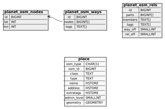
The planet_osm_* tables are the usual backing tables for OSM data. Note
that Nominatim uses them to look up special relations and to find nodes on
ways.
The osm2pgsql import produces a single table place as output with the following
columns:
osm_type- kind of OSM object (N - node, W - way, R - relation)osm_id- original OSM IDclass- key of principal tag defining the object typetype- value of principal tag defining the object typename- collection of tags that contain a name or referenceadmin_level- numerical value of the tagged administrative leveladdress- collection of tags defining the address of an objectextratags- collection of additional interesting tags that are not directly relevant for searchinggeometry- geometry of the object (in WGS84)
A single OSM object may appear multiple times in this table when it is tagged
with multiple tags that may constitute a principal tag. Take for example a
motorway bridge. In OSM, this would be a way which is tagged with
highway=motorway and bridge=yes. This way would appear in the place table
once with class of highway and once with a class of bridge. Thus the
unique key for place is (osm_type, osm_id, class).
How raw OSM tags are mapped to the columns in the place table is to a certain degree configurable. See Customizing Import Styles for more information.
Search tables🔗
The following tables carry all information needed to do the search:
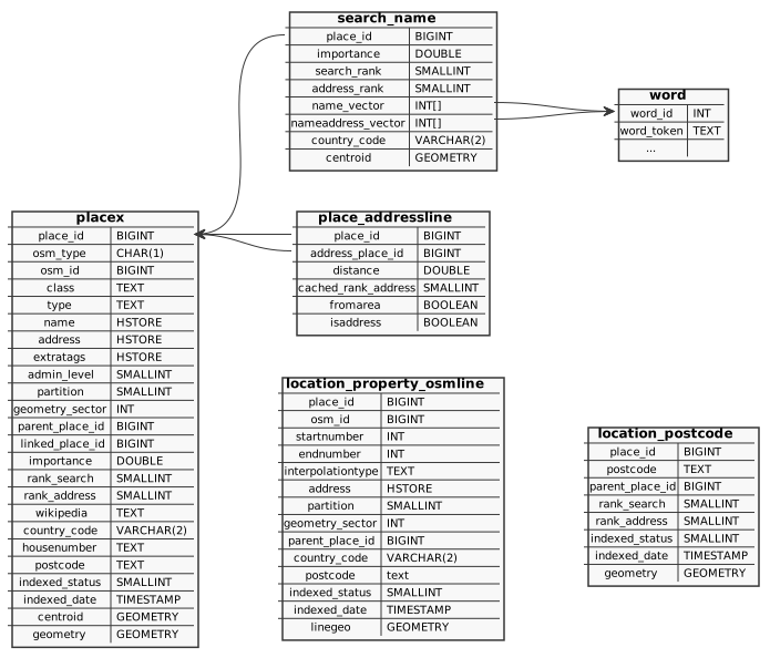
The placex table is the central table that saves all information about the searchable places in Nominatim. The basic columns are the same as for the place table and have the same meaning. The placex tables adds the following additional columns:
place_id- the internal unique ID to identify the placepartition- the id to use with partitioned tables (see below)geometry_sector- a location hash used for geographically close orderingparent_place_id- the next higher place in the address hierarchy, only relevant for POI-type places (with rank 30)linked_place_id- place ID of the place this object has been merged with. When this ID is set, then the place is invisible for search.importance- measure how well known the place isrank_search,rank_address- search and address rank (see Customizing rankingwikipedia- the wikipedia page used for computing the importance of the placecountry_code- the country the place is located inhousenumber- normalized housenumber, if the place has onepostcode- computed postcode for the placeindexed_status- processing status of the place (0 - ready, 1 - freshly inserted, 2 - needs updating, 100 - needs deletion)indexed_date- timestamp when the place was processed lastcentroid- a point feature for the place
The location_property_osmline table is a special table for address interpolations. The columns have the same meaning and use as the columns with the same name in the placex table. Only three columns are special:
startnumberandendnumber- beginning and end of the number range for the interpolationinterpolationtype- a stringodd,evenorallto indicate the interval between the numbers
Address interpolations are always ways in OSM, which is why there is no column
osm_type.
The location_postcode table holds computed centroids of all postcodes that can be found in the OSM data. The meaning of the columns is again the same as that of the placex table.
Every place needs an address, a set of surrounding places that describe the location of the place. The set of address places is made up of OSM places themselves. The place_addressline table cross-references for each place all the places that make up its address. Two columns define the address relation:
place_id- reference to the place being addressedaddress_place_id- reference to the place serving as an address part
The most of the columns cache information from the placex entry of the address part. The exceptions are:
fromarea- is true if the address part has an area geometry and can therefore be considered preceiseisaddress- is true if the address part should show up in the address output. Sometimes there are multiple places competing for for same address type (e.g. multiple cities) and this field resolves the tie.
The search_name table contains the search index proper. It saves for each place the terms with which the place can be found. The terms are split into the name itself and all terms that make up the address. The table mirrors some of the columns from placex for faster lookup.
Search terms are not saved as strings. Each term is assigned an integer and those integers are saved in the name and address vectors of the search_name table. The word table serves as the lookup table from string to such a word ID. The exact content of the word table depends on the tokenizer used.
Address computation tables🔗
Next to the main search tables, there is a set of secondary helper tables used to compute the address relations between places. These tables are partitioned. Each country is assigned a partition number in the country_name table (see below) and the data is then split between a set of tables, one for each partition. Note that Nominatim still manually manages partitioned tables. Native support for partitions in PostgreSQL only became usable with version 13. It will be a little while before Nominatim drops support for older versions.
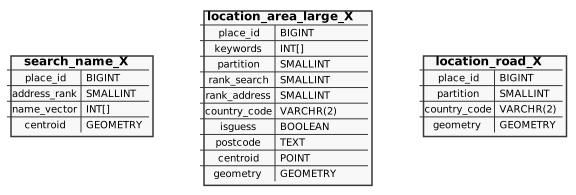
The search_name_X tables are used to look up streets that appear in the
addr:street tag.
The location_area_large_X tables are used to look up larger areas
(administrative boundaries and place nodes) either through their geographic
closeness or through addr:* entries.
The location_road_X tables are used to find the closest street for a dependent place.
All three table cache specific information from the placex table for their selected subset of places:
keywordsandname_vectorcontain lists of term ids (from the word table) that the full name of the place should match againstisguessis true for places that are not described by an area
All other columns reflect their counterpart in the placex table.
Static data tables🔗
Nominatim also creates a number of static tables at import:
nominatim_propertiessaves settings that must not be changed after importaddress_levelssave the rank information from the ranking configurationcountry_namecontains a fallback of names for all countries, their default languages and saves the assignment of countries to partitions.country_osm_gridprovides a fallback for country geometries
Auxiliary data tables🔗
Finally there are some table for auxiliary data:
location_property_tiger- saves housenumber from the Tiger import. Its layout is similar to that oflocation_propoerty_osmline.place_class_*tables are helper tables to facilitate lookup of POIs by their class and type. They exist because it is not possible to create combined indexes with geometries.