New Feature: Entrance information
Nominatim has recently added a new kind of details to its results: entrances. This post explains what the new feature looks like and why that is useful.
One of the important applications for geocoding is routing: you give the router a start and a destination address and then expect it to find a route in between. Start and destination address are usually sent to a geocoder to convert them into a set of coordinates. The problem here is that geocoders and routers have a slightly different view of the world: when a geocoder is asked for an address, it will return the building that belongs to the address. The router on the other hand only knows about the road network. So it has to make an educated guess on which street you actually want to start your journey. That usually works okay for smaller buildings but when it comes to larger structures like parks or airports the outcome might not be what you expect:
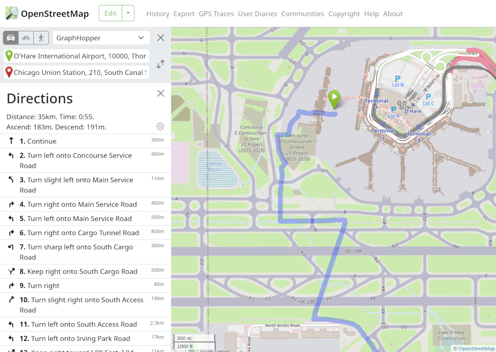
That’s where entrances come into play. Instead of just returning the center point of a location, Nominatim now adds the information where the location can be entered and exited. An entrance is usually much closer to a street from which the router can start the journey. Here is an example for Comox Airport, British Columbia:
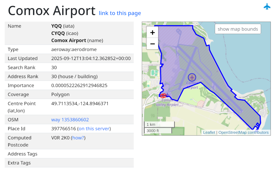
The blue circle describes the point that Nominatim returns to the router per default. The red circles are the entrances. Using them, them router can bring you right to the terminal.
To use the new information, add the
entrances=1
parameter to your request. If the result has entrance information an
entrances field with a list of entrances will be added. For each entrance
you get its type, coordinates
and any extra tags that might be available. Please give it a try, especially
if you are writing or using a routing engine, and
let us know
what kind of information about the entrance is useful for you.
Entrances are widely mapped in OpenStreetMap but not much used so far. That means that the tags around entrances are not well standardized yet. Making them more visible and usable through Nominatim hopefully helps getting a wider discussion going. There are a couple of limitations to the new entrance feature that need more discussion:
- Entrances are only added for OSM ways. Multipolygons or sites that are
mapped as OSM relations are currently ignored because it is unclear where
to look for entrances. There is a proposal for a special
entrancemember for relations but it isn’t widely used yet. Another option would be to look for entrances onoutermembers. - When dealing with complex locations like shopping malls or airports, then finding the routing endpoint can become much more complex than just going to the main door. The right access point may depend on your mode of transport, the purpose of your visit (departure or arrival) and which parts of the location you want to access. This might need more fine-grained tagging in OSM or it might be solved through more complex routing algorithms or more precise geocoding.
- Entrances are of limited use, when the location you want to get to is part of a larger complex with special entrances. To reach an address in a gated community, you need to be routed to the guest entrance of the community, not the address directly. As before, there is no suitable tagging for OSM yet, to express such a fact.
Entrance output is available in preview on https://nominatim.openstreetmap.org. Right now only entrances for recently edited data is available. You can check in the details view of the Nominatim UI, if entrances for a location are in the database: search for the location, then click on ‘Details’.
Many thanks to @emlove for implementing this new feature and to @mtmail for adding entrance display to the Nominatim UI.